SkyDemon Navigation Features
The navigation features in SkyDemon are all designed to keep you safe and well-informed during your flight. You'll spend less time worrying about your navigation and more time looking out of the window enjoying the experience.
During your flight SkyDemon will guide you effortlessly between your waypoints and notify you of potential hazards. At your destination airfield you can take advantage of georeferenced plates to make an approach using a detailed local map as a guide, or simply use them to navigate your way around unfamiliar taxiways.
The flight planning features in SkyDemon are all designed to make planning a flight less tedious and more interesting, by bringing the very best aeronautical briefing information directly to your fingertips in real time as you explore our charts and experiment with potential journeys.
SkyDemon will help give you the confidence to fly further and to more interesting places. Plan a journey, brief yourself on potential hazards, prepare for flight and analyse your track logs. Live briefing data includes NOTAM, airfield documents and maps, TAF, METAR and wind forecasts at altitude.
The charts are widely recognised as being the clearest aeronautical charts available. They are entirely bespoke, created by SkyDemon every 28 days (at least) directly from raw aeronautical data published by the countries covered. This means that wherever you fly, the look and feel of your chart is consistent.
Route Planning Made Easy
Planning a route with SkyDemon is as simple as clicking on, or touching, consecutive waypoints on the map. This intuitive method of route planning was pioneered by SkyDemon and is one of the hallmarks of our software's simplicity of use. Once configured, the route can easily be adjusted by dragging legs to create diversions. In this way you may find yourself planning many fantasy flights of the future.
As you plan, SkyDemon obtains all the briefing information necessary for your flight in real time (more about that below) so that accurate readings of total distance and time are always available. Some of this information is used to create the Pilot Log, which you can view or print at any time and includes essential information like which headings to fly and your minimum safe altitudes. It also includes enroute frequencies and radio navigation aids you are likely to use.
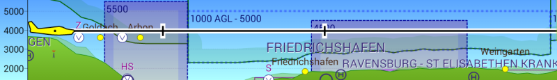
You will see warnings displayed in real time as you plan. Warnings include penetration of controlled or dangerous airspace, a temporary restricted area created by NOTAM, and planning to fly a leg lower than is safe. As with our charts, the types of warnings shown are configurable to your own preferences.
Virtual Radar and Useful Warnings
Virtual Radar approaching Friedrichshafen from the south
Arguably the most significant instrument in SkyDemon, virtual radar comes to life when you are in navigation mode. It continuously sends out virtual pings into our aeronautical data and presents the returns in a dedicated instrument at the bottom of the screen. It shows a real-time projection of your trajectory ahead relative to terrain, airspace, NOTAM, ground-based obstacles and other features. Your vertical speed is clearly represented, making it easy to see where your climb or descent will take you over time. In the background your planned route is visible, so you can see when it's time to begin a long climb or descent to achieve a specific level at a specific time.
If you're flying towards controlled or dangerous airspace you'll see a warning including advice on which service to call to gain penetration where available. We also include NOTAM warnings so you'll even be kept safe from temporary hazards which may only have been notified on the morning of your flight; things like aerobatics and military training. If you're flying at lower levels you'll appreciate our obstacle warnings.
View Progress and Make Changes
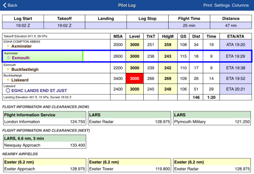
The Live PLOG enroute from Axminster to Exmouth
The instrumentation while you're flying is designed to be simple and show just what you need. A simple direction indicator with a bug on its compass rose is all you need to stay on course. Other instruments show the wind conditions outside, distances and timings left to run. A permanent position report makes it easy to give ATC a plain-English description of your position at any time.
A touch on the position reading takes you straight to the Live PLOG. This document is updated in real time with your progress through your planned journey. It shows your ETA at all future waypoints, and your ATA at waypoints you have passed. It shows the frequencies you might need based on your current position and altitude, including all Flight Information Services. It shows the radio services offered by all nearby airfields, all updated in real time.
Because the Live PLOG is much like the Pilot Log you will have used when planning your flight, you can use it to make changes to your route too. This can include taking a shortcut straight to a waypoint further on in your route because you have gained a clearance, or inserting a new waypoint between two others because you need to avoid something.
If you should have a sudden need to divert, you will bring up the Direct To feature. This quickly lists all nearby airfields with their longest runways, and at the touch of a button you can instantly plot a route directly to the destination of your choice. A valid NOTAM briefing will still be available even if you don't have an internet connection, because SkyDemon stores all NOTAM for the FIRs you will be flying in.
Approaching your Destination
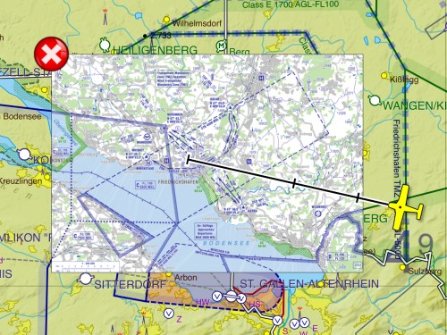
A georeferenced plate embedded into the SkyDemon chart
As you draw near to your destination you'll notice extended centrelines from the runways projecting out on to the map. These are a useful tool to orient yourself relative to the runway and circuit pattern early. For larger airfields you can even nominate an approach runway and use our pseudo-ILS feature to precisely line up on the extended centreline, helping to ensure a smooth and steady descent.
A wealth of documentation is available at your fingertips for every airfield, and especially your destination. Simply touch the information button next to the airfield to be taken to the Airfield Information screen, where you'll see the runway layout, frequencies, elevation, local weather, applicable NOTAM and available plates from the AIP and third-party publishers.
Many airfield plates include a richly detailed local map, either for approach or airfield diagram purposes. Most of these are georeferenced, which means you can embed them into your SkyDemon chart at the touch of a button and fly inside them. This is hugely beneficial for spacial awareness, and can help you make a textbook approach or navigate your way through a confusing system of taxiways once landed.